But Darwin only had part of the answer. A more complete answer to the origin of the Galápagos could not be had until after 1958, when continental drift, or plate tectonics, was discovered. We now understand that the surface of the earth is divided into massive tectonic plates which slowly drift across the globe. The formation of the Galápagos is intimately tied to the history of the Nazca plate, on which they lie.
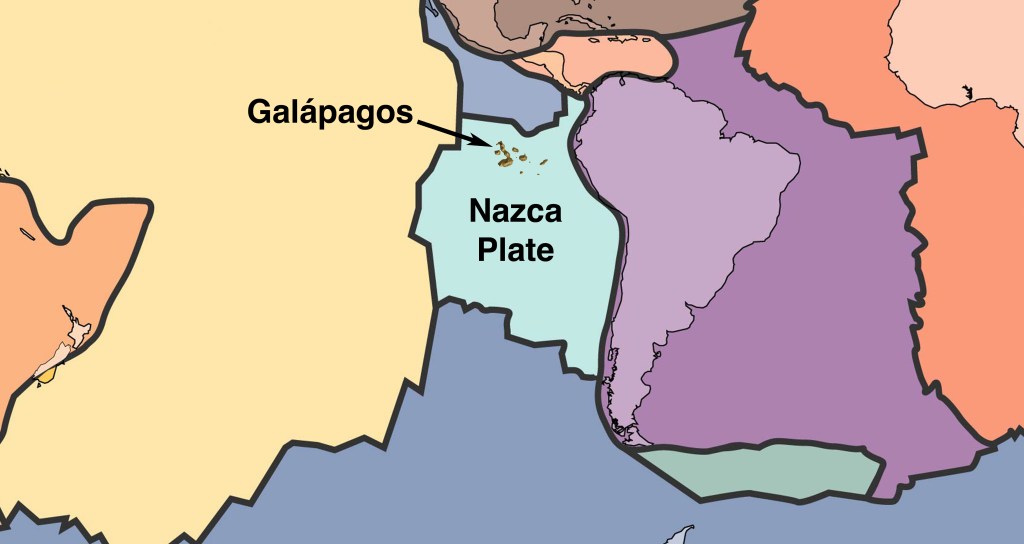
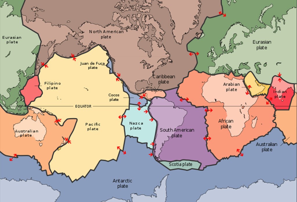
The Galápagos are located on the northern edge of the Nazca plate, which is bounded by the Cocos (north), the Pacific (west), the South American (east), and the Antarctic (south) plates. The Nazca plate itself is currently drifting south, away from the Cocos plate, and east, away from the Pacific plate. Since the net direction of drift is southeast, the Nazca plate is colliding with the South American plate. At the point of collision, the South American plate, which is made of light continental crust, is riding up over the Nazca plate, which is made of dense oceanic crust. This type of plate interaction is called subduction.
As the Nazca plate is forced into the mantle, it melts and its melt products work their way up to the surface to form volcanoes. The land is further raised by the crumpling effect as the western edge of the continent rides up over the descending plate. The result is the Andes, a young, highly volcanic, rapidly growing mountain chain. This same movement of the Nazca plate is responsible for producing the cluster of volcanic islands we call Galápagos.
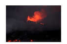
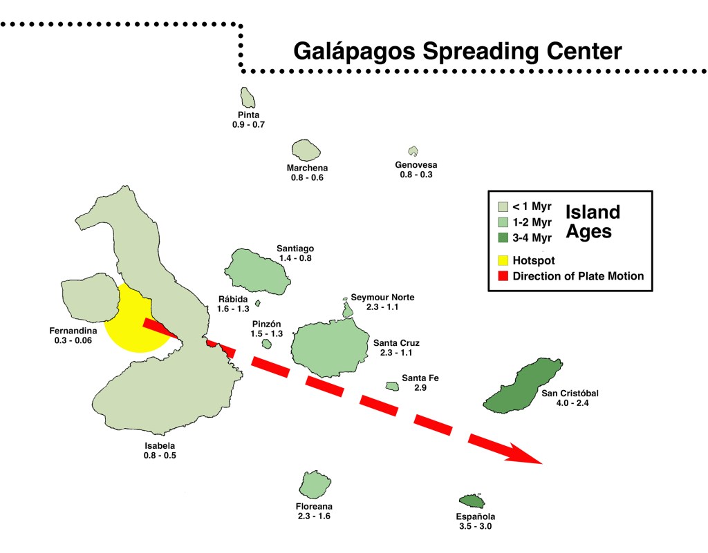
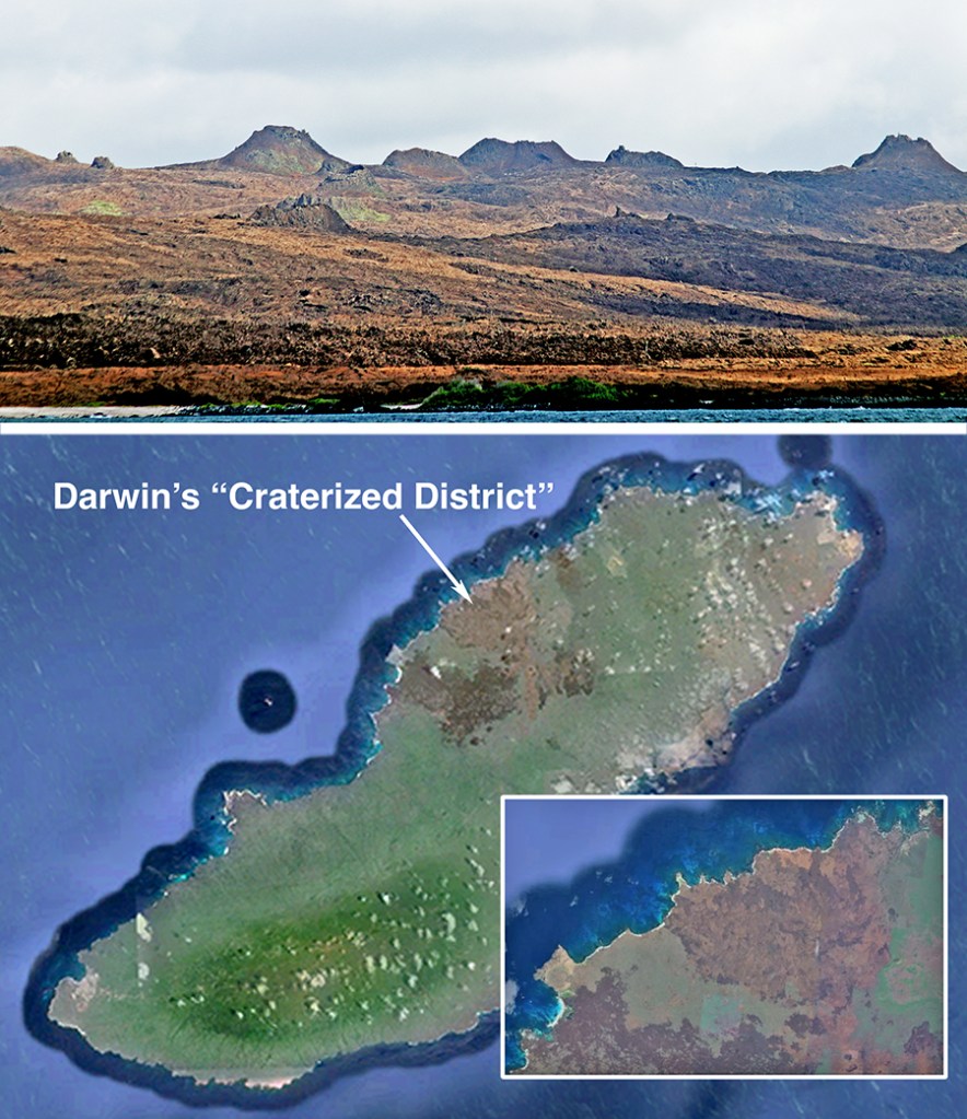
There is a large body of geophysical evidence for the existence of enormous plumes of hot mantle material that originate deep in the mantle and rise all the way to the lithosphere. These plumes seem to be stable over many millions of years. and with time, they burn through the crust to form an underwater volcano. Eventually a submarine platform builds up and finally breaks the surface to form an island. The platform receives an added boost because the intense heat reduces the density of the overlying lithosphere, making it float higher on the mantle than the surrounding cooler crust. These mantle plumes, called hotspots, are believed to be stable over millions of years, so island building will continue and a new link in the island chain will form. The original platform will ultimately be extended to a ridge that supports a string of volcanic islands. Islands farthest from the hot spot are older and more eroded while islands near or on the hot spot are younger and steeper. Thus, San Cristóbal, the nearest to the mainland, is approximately four million years old and composed of eroded, rounded cones, while Fernandina dates at less than 7000 years and is considered to be one of the most active volcanoes in the world.
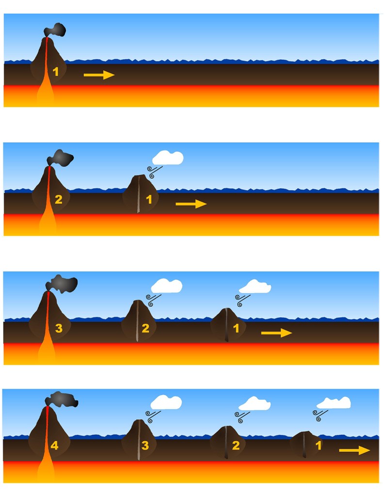
Upon becoming subaerial, the nascent island is now subject to weather and wave erosion, but if volcanic activity outstrips erosion, the island will grow. Eventually, movement of the overlying plate will carry the island off the hot spot and it becomes increasingly disconnected from its magma supply. As volcanic activity dies down and eventually ceases, erosion becomes the dominant force shaping the island. With reduced heating, the lithosphere cools, becomes denser, and sinks back into the mantle, ultimately dragging the island below the waves. Just before disappearing, wave action shears off the top of the island, turning it into a flat-topped guyot. Recently former Galápagos islands, now submerged, have been discovered between Isla San Cristóbal and the mainland. This discovery significantly increases the age of the archipelago. Indeed, several million years from now the present islands may likewise sink beneath the waves only to be replaced by a new set of Galápagos Islands. Who can imagine what course further evolution will take!?
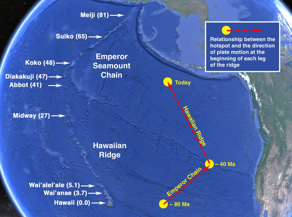
The Hawaiian Islands are a classic example of this process. Beginning more than 80 million years ago (Ma), the Pacific plate was moving in a northerly direction, passing over the hotspot that ultimately formed the island of Hawaii. As it passed over, the Emperor Seamount Chain was built up. Around 40 Ma, the plate changed direction and began to move northwesterly, beginning the construction of the modern Hawaiian chain. 27 Ma the Midway Atoll passed over the hot spot and now the big island of Hawaii is there. The next island in the Hawaiian chain is in the process of being formed right now. Just 28 km southeast of Hawaii, nearly 1000 m below the sea is the Loihi seamount. Loihi has two summit craters and very young pillow lavas. In a few thousand years, it may become the next Hawaiian island.
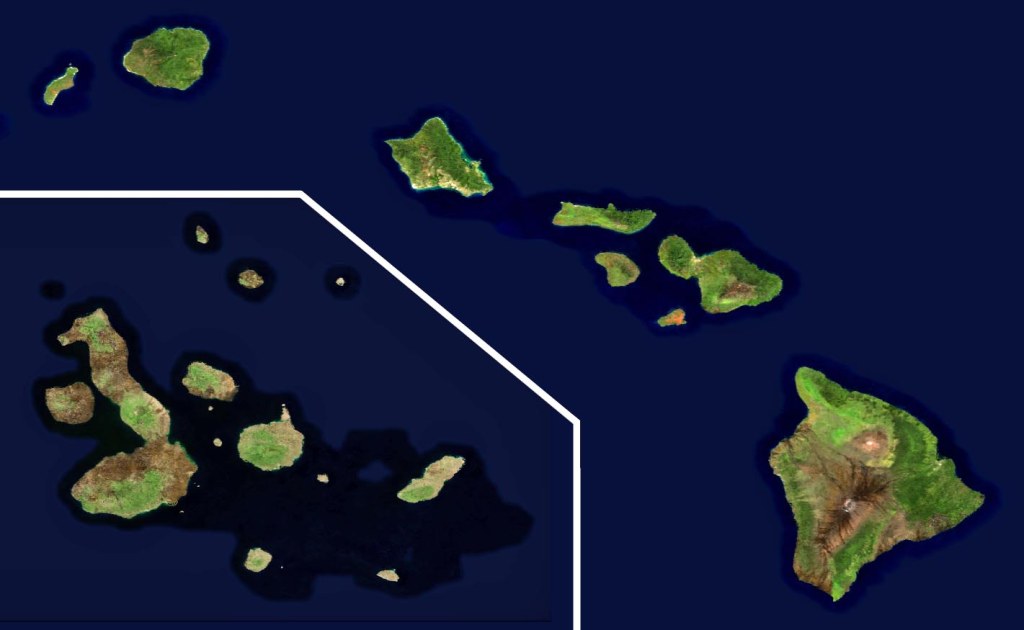
There are many striking similarities between both the formation and the geology of the Hawaiian and Galápagos archipelagos, but there are important differences as well. While the Hawaiian Islands are strung out in a linear chain from youngest to oldest, the Galápagos are more clustered.
To be sure, age increases from west to east, but only in a general sense. The northern islands of Genovesa, Pinta, and Marchena are young, like Isabela and Fernandina, but their ages are anomalous relative to their position within the archipelago, and they do not lie in line with the direction of plate movement.
In Hawaii, once an island has moved off the hotspot, volcanism seems to have ceased abruptly. In San Cristóbal, on the other hand, volcanism has continued for more than a million years, and there have been occasional eruptions in the central islands.
The seafloor beneath the two archipelagos seems to be quite different owing to their positions relative to the boundaries of their plates. Hawaii lies in the center of the Pacific plate while the Galápagos lie very close to the boundary between the Nazca and Cocos plates. These two plates are the remnants of a much larger plate, the Farallon, which has been drifting eastward toward the Americas. Because the west coast of North America extends farther to the west than the west coast of South America, the Farallon plate has mostly been subducted under North America. The only northern remnant is the small Juan de Fuca plate off the Pacific Northwest coast. About 25 Ma the remaining southern remnant of the Farallon plate split into what is now the Cocos and Nazca Plates. The Galápagos hotspot lies near the boundary between the two.
The Galápagos lie at the apex of two ridges, the Carnegie and the Cocos. The seafloor between the two ridges, called the Panama Basin, is extremely complex. Studies of the basin reveal a number of failed spreading centers running at different angles than the actual spreading center. Apparently, the spreading center has shifted in stages from its original direction to its present east-west orientation. As the spreading center shifted, the hotspot was sometimes to its north, sometimes to its south. Thus, both the Carnegie and Cocos ridges are traces of the same hotspot. The two ridges mirror one another. When one ridge was being built up, the other languished, and this is reflected in the bathymetry. This appears to have left the Panama Basin fragile, permitting extended volcanism from the upper mantle even though the island is no longer receiving magma directly from the hotspot.
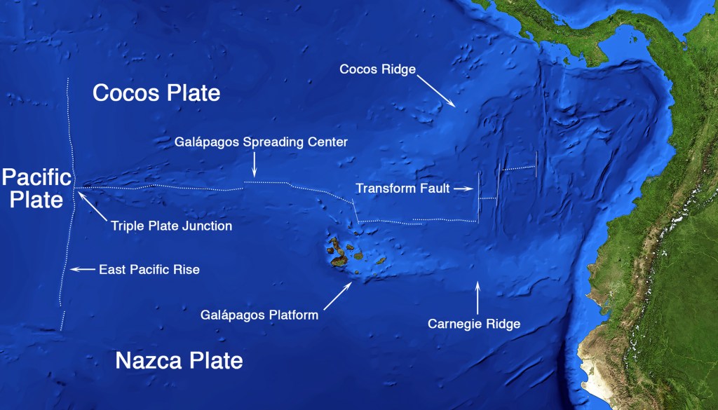
The anomalous northern islands have a different origin. Small seamounts are often found alongside spreading centers in other parts of the world. While these seamounts could potentially become subaerial, they do not receive enough heat and. magma to do so. However, in the Galápagos, there appears to be an interaction between the spreading center and the hotspot. Enough heat and magma seem to have flowed from the hotspot to the spreading center to boost the growth of these typical seamounts to the point where they were able to break the surface as Marchena, Pinta, and Genovesa.
Find out more about Galápagos Geology in Volume 1 of
A Paradise for Reptiles.