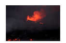
As hot as lava seems, it can cool and solidify even while flowing. When the sides of a flow chill and harden they form natural levees. If the surface of such a channeled flow also forms a crust, then the molten lava underneath continues to flow, and when it finally drains away, it leaves behind a long, empty lava tube. Such tubes can be quite small, but can also form immense caves. This occasionally occurs on a’a flows but is an important feature of pahoehoe flows.
On pahoehoe flows, tubes can be formed both near the vent and at the far end of the flow. Near vent tubes are formed when the flow surface cools and crusts over while molten lava continues to flow in channels underneath. If the flow rate is sufficiently high, lava can even erode down into underlying layers to form large tunnels. At the far end of the flow, tubes form by the coalescence of tongues of lava. Movement forward at the flow front is impeded by the cooled crust but eventually pressure of new lava from behind causes the flow front to rupture, emitting tongues of new lava. As new tongues flow over and under older tongues, the tongues may coalesce into larger conduits. At the end of the eruption, the channels drain leaving behind a lava tube. In many cases, lava tubes are quite small, such as at Bartolomé, but they can also reach diameters of 5-10 m and lengths of several kilometers. Over time, it is not uncommon for lava tubes to form one on top of another. Then, the floor of an upper tube can collapse into the lower, enlarging the chamber. Later, portions of the roof may collapse, allowing entrance into the tube.
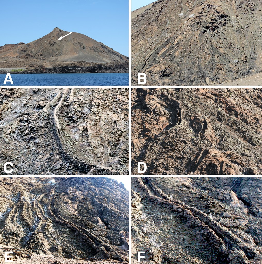
Bartolomé offers excellent examples of small tubes and levees. In the figure below, (A) is a view of the main cone, the summit of which offers a spectacular view of Pinnacle Rock, the tuff cone Cerro Inn, and the extensive Bahia Sulivan lava flow. There is a vent part way up the slope (arrow) from which a number of lava channels emerge. (B) is a detail. (C) and (D) are small lava tubes, probably the size of one’s thigh, with partially collapsed roofs. (E) shows several levees, and (F) is a detail. These features are easily seen from the boardwalk that runs by the base of the slope and ultimately climbs to the summit.
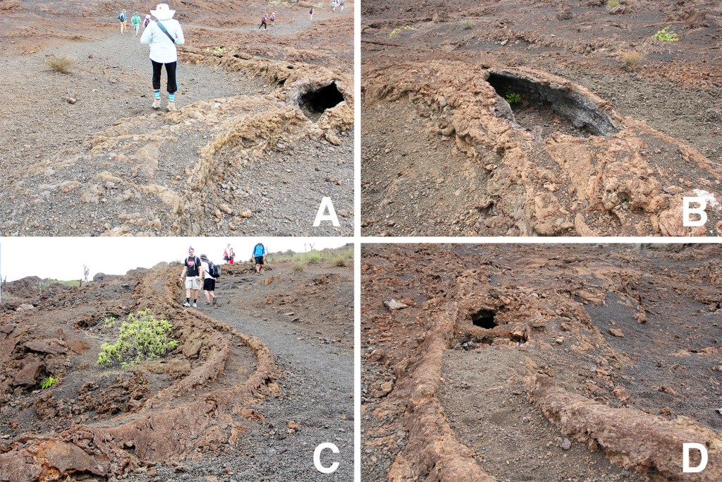
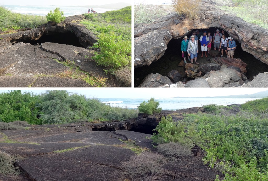
The photographs below are of a larger lava channel running alongside the trail from Sierra Negra down to Volcán Chico, Isabela. (A) and (B) are at the beginning of the channel looking downhill while (C) is from the end looking uphill. At the beginning, the channel has a roof with a partial collapse, but as it continues downslope the channel becomes a levee. That the difference between the two sections is a change from tube to levee is obvious when comparing the edges of the broken roof (B) with the edges of the levee. Finally, just before the channel disappears, it reverts back to a tube (C and D).
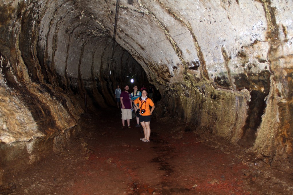
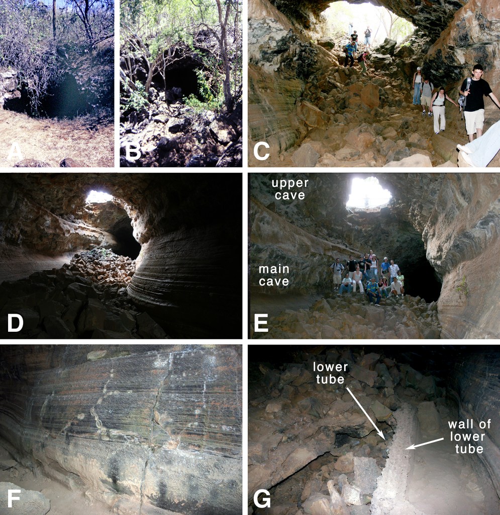
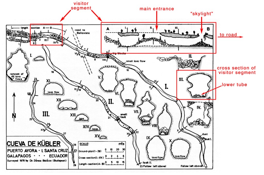
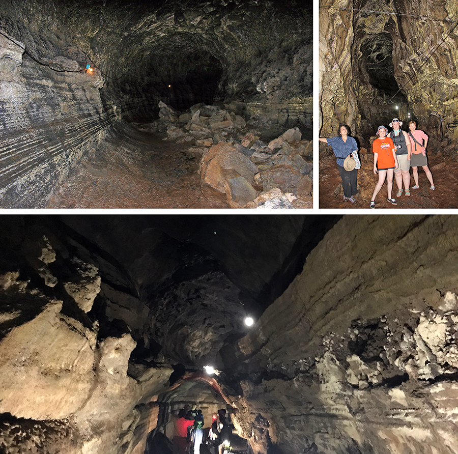
The largest lava tubes that are open to tourists are on Santa Cruz, the most accessible being one just outside Puerto Ayora just off the road up to Bellavista. This cave was discovered by an early German settler, Karl Kübler, and was known, accordingly, as La Cueva de Kübler. It has over time been known by other names such as El Tunnel, La Cueva de Puerto Ayora, and, currently, El Mirador. The cave was surveyed in 1970 by Hungarian geographer and karst researcher Dénes Balázs.* La Cueva de Kübler, as Balázs called it, is 852 m long (just over half a mile), nearly 6 m high and 5.5 m wide. The portion of the cave that is actually visited is quite small, corresponding to the section A—B on the Balázs’s map below. The height of the ceiling is increased by the breakthrough of a smaller parallel tube running above the main cave, and a later eruption has left a small tube whose roof is also collapsed, running along the floor of the cave. Along the walls are marks showing past levels of lava as it flowed through the tube and ultimately drained away. At the distal end of the tunnel solidified lava reduces the height of the tube from an initial 10-12 m to only 2-3. There are two entrances to the tunnel. The first, about 25 m from the road, is a small opening in the roof, creating a “skylight” in the cave’s ceiling. I was amused by a National Geographic video about the Galápagos that showed the host being lowered by tackle into the cave through this skylight. It all seemed dark and mysterious. However, another 40 m or so farther down the trail there is a much bigger opening in which the block-like fragments of the collapsed roof form a relatively easy staircase into the cave. That’s how they got the big IMAX camera into the cave to film the host’s descent. In the photos below, (A) is the skylight and (B) is the main entrance. I have visited this cave many times, but on my last visit in 2023 it was barricaded off. Our guide did not know why it was closed or if it would be re-opened.
*Balázs, D. 1975. Lava Tubes on the Galápagos Islands. National Speleological Society Bulletin 37 (1): 1-4.
There are other lava tubes in the Santa Cruz highlands that are open to visitors, most notably Los Tunneles at Bellavista, Rancho Primicias, and Rancho El Chato 2. This later cave features a beautiful example of full-size upper and lower caves.
Bottom: Ranch El Chato 2. Note the fully developed upper cave
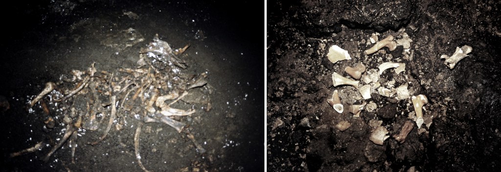
The end of the trail at Post-Office Bay on Floreana also features a lava tube, now closed to visitors. Lava tubes have been traps for animals and it is not uncommon to find bones inside. In one Santa Cruz cave I found the skeleton of a cow that had had become trapped, and when I visited the Floreana cave in 1989, I saw a few moldering bones of giant tortoises, now extinct on that island. These few fragments are the remains of a rich trove of tortoise skeletons that have been removed from the cave. Those skeletons are the primary source of information about the resident Floreana species, Chelonoidis niger. See my Giant Tortoise post for a brief description and a photograph of a tortoise carapace from the cave. Volume 1 of A Paradise for Reptiles offers a more detailed discussion of tortoises from this cave.
As well as information about the hapless tortoises that were trapped in lava caves, the caves provide a window on other extinct species. In an environment that offers little opportunity for fossilization, ancient owl pellets in the cave have yielded the bones of extinct rice rats, finches, and other small animals.
In addition to the highland lava caves, there are a number along the coast, running out to sea. El Túnel de Estero lies just off the trail from Puerto Villamil, Isabela, to the Wall of Tears, the remains of an Ecuadorian prison camp, and is a relatively small, intact tube. But there are larger, more degraded lava tubes at other sites. The Fur Sea Lion grotto is the remains of a lava tube in which an arch is merely a fragment of the cave’s roof. There, fur sea lions sequester themselves in the relative dimness of the rocky ledges while they wait to begin their nighttime forays. At one time, snorkeling was permitted in the grotto. The photograph here is at low tide. At high tide it was necessary to dive under the arch. Another vestige of the tunnel, Darwin’s Toilet, lies just a few meters inland from the grotto. This is smaller opening into the tube in which sea water rises and falls with the ebb and flow of waves. Cabo Rosa, Isabela, is an extensive area of broken, flooded lava tubes. As can be seen from the Google Earth image, it is an archipelago of pillars and arches, all that is left of a complex network of lava caves. The primary visitor activity there is snorkeling, and it is a positively amazing experience.
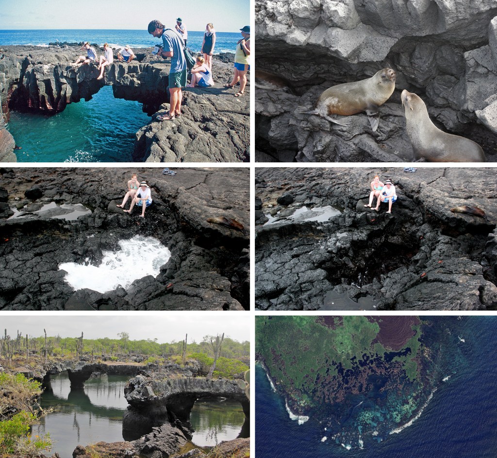
Middle: Darwin’s Toilet
Bottom: Cabo Rosa and Google Earth image
Find out more about Galápagos Geology in Volume 1 of
A Paradise for Reptiles.