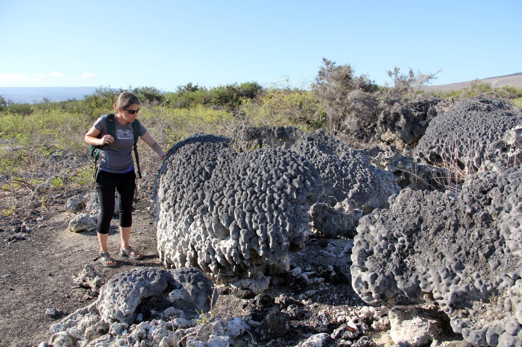
Elevation of the land — Proofs of the rising of the land are scanty and imperfect. At Chatham [San Cristóbal] Island, I noticed some great blocks of lava, cemented by calcareous matter, containing recent shells; but they occurred at the height of only a few feet above high-water mark. One of the officers gave me some fragments of shells, which he found embedded several hundred feet above the sea, in the tuff of two craters, distant from each other. It is possible, that these fragments may have been carried up to their present height in an eruption of mud; but as, in one instance, they were associated with broken oyster shells, almost forming a layer, it is more probable that the tuff was uplifted with the shells in mass.
–Charles Darwin, Geological Observations on Volcanic Islands
Most of my Galápagos trips begin at the airport on Baltra, and I always try to get a seat by the window on the left side of the plane (seat A), not too close to the wing. Like clockwork, about 90 minutes after leaving the mainland we fly over San Cristóbal, and then a few minutes later the plane swings north of Seymour Norte and then loops around to the south to come in for a landing at the Baltra airport (now called Aeropuerto Seymour). Just at that turning point, if I am seated in a row where the wing doesn’t obscure the view and the sky is clear, I look out the window and see this view:
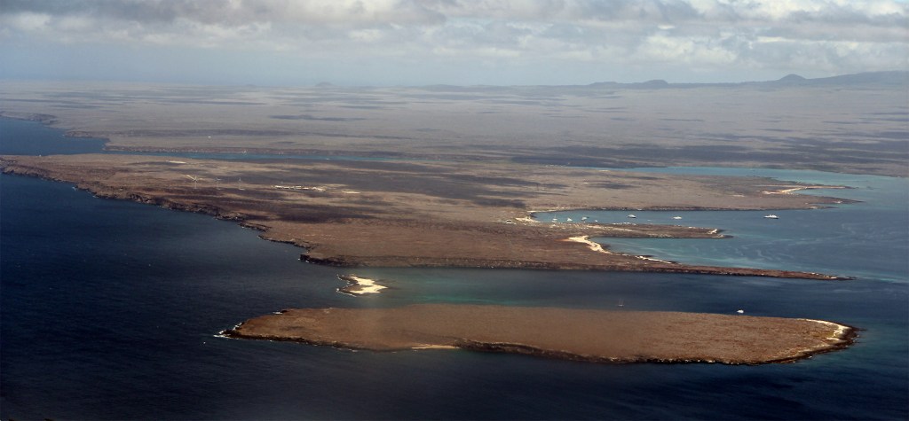
The view is magnificent. Breathtaking. Emotional. But beyond that, the view has much to say about the natural processes that shaped the Galápagos. For one thing, in some years the overall color is gray, as here, and in others it is green. A dry year or a wet year. The island in the mid-ground is Baltra, separated by the Canal del Norte from Seymour Norte in the lower part of the photo (there is no Seymour Sur; that is the original name for Baltra. The meaning of the name is now lost). The small white islet between Baltra and Seymour Norte is Mosquera, little more than a sand spit, but an interesting visitor site, nonetheless. Far to the south, Baltra is separated from Santa Cruz by the Canal de Itabaca.
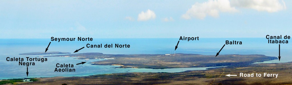
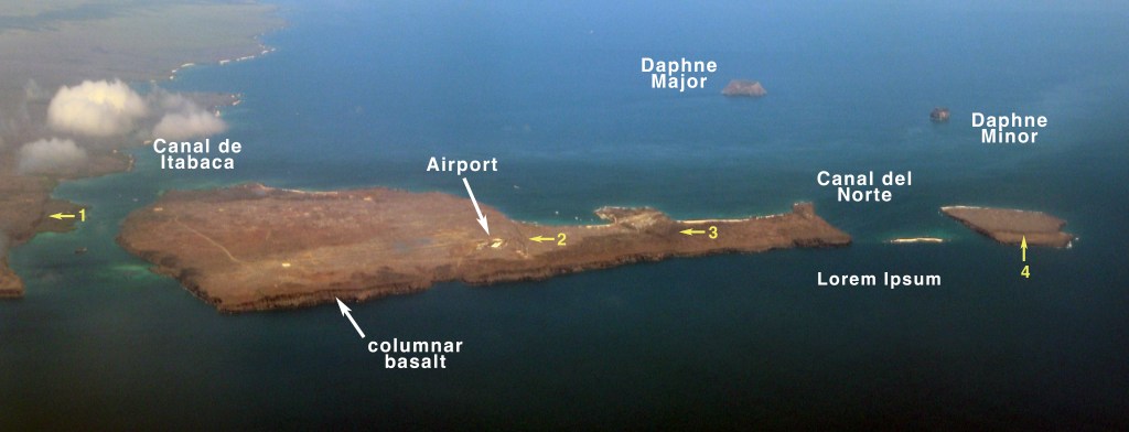
The reciprocal view can be seen from the highlands of Santa Cruz. There is a large sand and gravel quarry around kilometer 33 on the cross Santa Cruz road leading down to the ferry to the airport. Our guide took us there on one of my early Galápagos trips, and while it is not a visitor site, I always bring my students there. The site is highly disturbed but one can always find endemic Galápagos tomatoes and peppers in abundance, and lots of Darwin’s finches and lava lizards as well. But the main reason for going there is the view. Apart from being beautiful and inspiring, these two views illustrate one of the major geologic processes that have shaped the Galápagos – uplifts and down drops (horsts and grabens), respectively.
Northern Santa Cruz and its satellites Baltra and Seymour Norte are the result of uplifts and down drops. The two canals, Itabaca and del Norte are grabens and the islands are horsts. Fault scarps (numbered yellow arrows), signs of vertical displacement, are clear on Baltra and Seymour Norte. The eastern side of Baltra is a steep cliff, and the island slopes down to sea level on the western side.
What is not clear from these aerial photographs is a prominent white layer of fossiliferous limestone in the cliff face of both islands. Originally formed underwater, this layer was uplifted and overlaid by subsequent eruptions. Darwin did not visit this area but in writing his autobiography later in life, he reminisced on a similar structure in St. Jago, Cabo Verde:
The geology of St. Jago is very striking yet simple: a stream of lava formerly flowed over the bed of the sea, formed of triturated recent shells and corals, which it has baked into a hard white rock. Since then the whole island has been upheaved. But the line of white rock revealed to me a new and important fact, namely that there had been afterwards subsidence round the craters, which had since been in action, and had poured forth lava.
“It then first dawned on me,” Darwin continued, ” that I might perhaps write a book on the geology of the various countries visited, and this made me thrill with delight.’
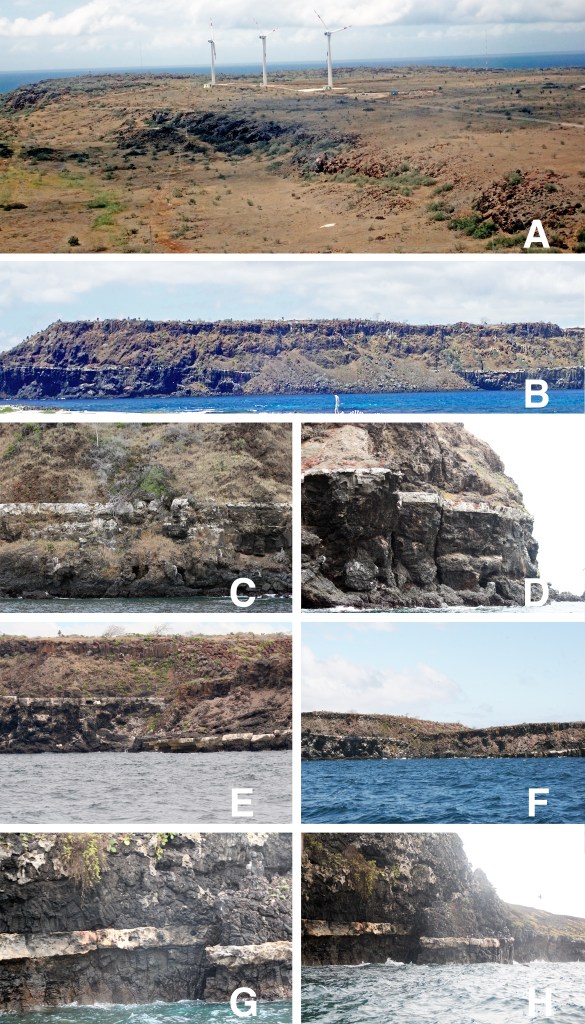
A. Fault scarp #2 near the airport
B. White limestone band as seen from Mosquera
C & D. Two views of the white limestone band in the wall of Baltra
E & F. Displacement of white band and resulting fault scarp #3 on Baltra
G & H. Displacement of white band and resulting fault scarp #4 on Seymour Norte
Near the eastern entrance to the Canal de Itabaca., Baltra’s cliff face offers another feature, columnar basalt, which I have not seen in other parts of the archipelago that I have visited. When basaltic subaerial lava flows and shallow magma intrusions cool, they frequently solidify as a series of jointed columns. The upper surface of the flow generally cools quickly enough that no regular structure forms, but in the hotter interior, cooling is slower and thermal stresses cause the lava to contract into regular polygonal (typically pentagonal or hexagonal) blocks that are separated from one another by joints. Once a block begins to form on the cooler outer surface, it propagates inward to the hotter interior, forming regular, vertical jointed columns. Columns beginning from the upper surface propagate downward and columns beginning from the bottom surface propagate upward forming paired upper and lower columns, called colonnades. Between the upper and lower colonnades there usually is a third layer of columns, the entablature. Unlike the colonnades, the columns of the entablature are irregular, often curved or tilted. The reason for this is unclear and may be related to deformation while the joints are still somewhat plastic. Each column is cut at various points along its length by perpendicular cross joints. This description of the three-part column structure is the ideal, but the presence and exact structure of each component is actually variable. In the Galápagos, colonnade and entablature components are clear on the cliffs, but the overall arrangement is somewhat disorganized relative to the ideal condition. Worldwide, the most famous basaltic column sites are the Devil’s Post Pile in California and the Giant’s Causeway in Ireland.
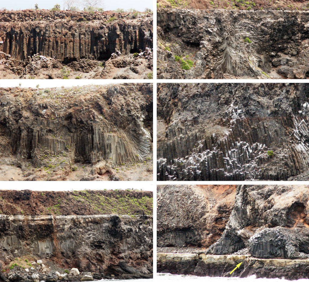
Baltra is an old island and there is no way of knowing how much time was necessary to effect the uplifts and down drops that gave the island its present shape. However, events at two well-known visitor sites, Punta Espinoza, Fernamdina, and Bahia Urvina, Isabela, reveal that localized shifts in elevation can happen very rapidly.

In1927 three fishing boats from Floreana were caught in an uplift at Punta Espinoza so sudden that while two boats were able to shove off, the third was already grounded. Between 1974 and 1976 a series of small earthquakes raised the site in increments by 80-90 cm. As a result of this uplift, the landing jetty is usable only at high tide and the remains of stranded mangroves provide shade for marine iguanas.

In 1955, a Disney crew was in the Galápagos filming for the “True Life Adventure” series when they encountered anomalously shallow water and a brilliant white beach that was not marked on their charts. Upon exploring, they found that the area had been uplifted by about 6 m, exposing nearly 1.5 km2 of seafloor and reef deposits. The uplift probably occurred in May 1954 and appears to have been very sudden, possibly within just one hour, stranding fish and sea turtles, which all could have otherwise easily swam away. Alternatively, however, the uplift could have involved the release of toxic gasses into the water. It simply is not clear. Today Bahia Urvina is a visitor site and a trail crosses the uplifted area. Along the way, one walks over broken coral fragments and cobbles that were once rolled by waves on the shore, and sees the blanched remains of tube worms and barnacles stuck to the rocks as they were when they were alive. At one point, the trail passes dead mangroves that once grew on the shoreline. The highlight is a cluster of large, stranded coral heads.
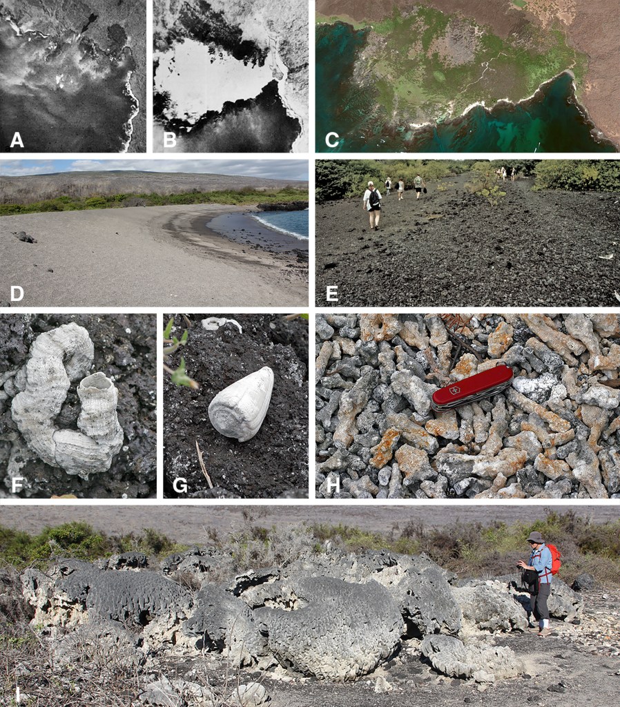
A & B. US Air Force photos of Bahia Urvina before and after the uplift
C. Google Earth image of Bahia Urvina today
D. Present day shoreline
E. Region of trail that appears to be original shoreline
F, G, & H. Tube worm, shell, and coral fragments along the trail
I. Uplifted coral heads
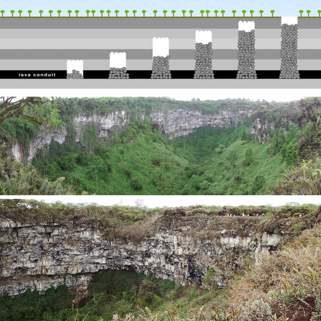
Withdrawal of magma from a magma chamber or conduit can lead to down drops resulting in calderas and pit craters. A pit crater is thought to form as a subsidence event when magma is withdrawn from below. Rather than being the simple drop of a piston-like block into an empty cavity, the subsidence occurs stepwise by a process known as “stoping.” The collapse begins when pieces of the conduit roof fall inward creating a void. Subsequently, pieces of the void’s roof drop down, filling the void and creating a new one above. With each roof collapse, the void is translated upward until it finally breaks the surface as a large, circular depression that can be tens of meters deep, revealing numerous lava flows in its walls. That the crater was not formed by an eruption, explosive or effusive, is attested by the lack of pyroclastics or lava around the crater. There are a number of pit craters on Santa Cruz that are easily accessible to tourists. Most frequently visited are Los Gemelos (Spanish for “the twins”), two craters that lie on either side of the main road that crosses the island. The visitor site at Cerro Mesa, where one might be lucky enough to see Chelonoidis donfaustoi, features a pit crater with a steep trail leading to the bottom.
Find out more about Galápagos Geology in Volume 1 of
A Paradise for Reptiles.